Tuesday, December 11, 2007

Sarah Allen - Postcard 2


November 28, 2007
Dating Glacial Moraines with Lichenometry

When a glacier temporarily stabilizes during its retreat, some of the sediment it is carrying gets deposited as glacial moraines. Moraines are most often composed of poorly sorted (wide range of grain sizes) sediment called glacial till. They can be deposited on the side (lateral moraine) or at the snout (terminal moraine) of a glacier. Moraines not only mark a previous location of a glacier, but they can be dated to provide a timeline of events.
One of the ways to date young Holocene aged moraines is with a technique called lichenometry. The green (algae) and black (fungus) symbiotic lichen, Rhizocarpon geographicum, is one of the first colonizers of exposed rock surfaces. These lichens grow slowly and can last hundreds of years. A growth curve can be calculated based on climate conditions and rock composition in an area. Once this is established, the five largest lichens found on any one moraine can be measured in millimetres and averaged to determine the approximate age of the moraine.

Sarah Allen - Postcard 1


November 19, 2007
Lake Taupo Terraces

Lake Taupo occupies a caldera, a collapsed volcanic chamber that erupted in AD 186. The caldera is much larger than the current lake level and this can be seen with the wave cut terraces (benches) that circle the lake. This photo, representing approximately 2 meters in height, shows one of these terraces. The interpretation of this site is not finite – it involves multiple working hypothesises, a common practice in geology. It could be the former edge of the lake, a fluvial or stream deposit, or a combination of both. The white pumice cobbles are well rounded and imbricated or shingled on top of each other, which is indicative of stream transport. The alternating layers of pumice and fine grained, well-sorted, sandy silt (possibly reworked volcanic ash) demonstrate a change in the energy of the system. Typically, larger particles need a higher energy environment to be moved and deposited, but it may be reversed in this case, since pumice is so porous that it floats. The fine material could also be floodplain deposits from the lake or a stream. The former shorelines/terraces can be correlated around Lake Taupo. The changes in lake level may be due to climate change, erosion, or a newly formed outlet.

Saturday, December 8, 2007


Mud Pools--> Rotorua, New Zealand In this area mud accumulates from volcanic ash over a geothermal active area. The heat source from underground heats up the turbid water, which rises towards the surface. This causes the bubbling of mud upwards, sometimes with great force spewing mud all over the place. This is an unstable area that can be very dangerous. The mud here is used for face masks, because it absorbs excess oils and impurities from within the pores, leaving smoother, softer skin. This absorption is due to the clay, which shrinks when it is dry and expands when wet. You could see the steam rising out of the mud, hear the bubbling burp noises, and smell the taint sulfur scent.


Kura Tawhiti Conversation Area--> These towering rocks referred to as Tors underwent long-term chemical weathering and are post glacier landmasses, so they are rather old. They are sedimentary rocks with some horizontal layering present but difficult to really see due to the years of erosion. More specifically these large boulders are remnants made up of limestone. Limestone is more easily corroded in natural acids than other rocks which gives the structures a scalloped rough surface. The boulders are broken by joints where water percolates and erodes, leaving these striking towers that stick out of the ground. The area is also an important site for the Maori people of the New Zealand, leaving rock art throughout the incredible landscape.

Friday, December 7, 2007


Mt. Ruapeho is an active composite volcano made of alternating layers of ash and rock. The rock type consists primarily of andesite and boulders that are strewn far and wide across the landscape indicating its prolific activity: it has a significant eruption every few decades with smaller one occurring more frequently with the last one in September 2007. Crater Lake sits in the mouth of the volcano and has a pH of 1 (greater acidity than the acid in stomach) and a temperature of 38◦C. The amount of water in the lake effects how large the resulting lahar will be and allows geologists to map where the lahar will flow. Lahars going down the volcano can attain speeds of 90 km/hr and can create devastating effects. Due to the volcano’s reach into the upper stratosphere, the volcano is often snow-capped and is used as a ski resort. The class hiked up Mt. Ruapeho in ~6 hours and went down the mountain in less then 2 hours thanks to the ability of trash bags to be used as sleds.

White Island was named by Captain Cook as he only sailed past it and didn’t explore it further as he would have found an active, stratovolcano created by pyroclastic lava flows and lahars. By visiting the volcano, one is able to stand on some of the newest continental crust on the earth which consists mostly of andesite and tefron deposits. White and yellow patches likened to a pie (cool crust and a hot center) dot the landscape and these colors are due to gypsum and sulfur, respectively. Fumaroles are also strewn across the island the mouth of the volcano has a dynamic lake that has dropped 30 meters in the span of 6 weeks. The lake is quite dynamic with its color changing constantly and its temperature ranging from 30-70◦C depending on its height. Due to the high concentration of hydrochloric and sulfuric acids, the lake has a pH of -0.6. The water in the lake comes from steam cooling and the lake can be a concern as if it rises too high and spills into the ocean, the abundant and diverse marine life surrounding the nutrient rich island would be damaged. The volcano was mined for its sulfur in the early 20th century and is now studied and monitored by scientists with a seismograph and web cameras located on the island and also by monitoring gas emissions. On the volcanic alert level that scales from 0 to 5, White Island volcano is given a 1. The highest point on the volcano is 321 meters high and is named Gismund Point.

Otira Valley on the South Island of New Zealand is a geologically active area. High erosion, uplift and rain lead to a lot of relief, high valleys and unstable slopes. These create frequent and intense landslides, posing serious threats to those who drive through this area. It is believed that there was one seismic event that caused the major destruction in this valley. 186 A.D. was the last major Taupo volcanic eruption, which probably had caused enough seismic energy and shock to initiate an epic landslide. Charcoal was found and dated back to 1900 BP, showing that the Taupo eruption could have a strong connection to the origin of the landslide. A viaduct was created in the valley to stabilize the road, as it previously built on top of a landslide. This project cost $25 million and was constructed over 2 years. This viaduct was created because it is well-resistant to earthquakes and is minimally affected by erosion from landslides. The viaduct can withstand earthquake stresses 40% more than all other forms of protection created in New Zealand. There are also V-supports that reflect landslide debris, these supports are visible on the 2 end piers, but not in the middle pier because this is not a big path for landslide debris. The overlying problem is that the alpine fault goes through this valley so it is very geologically active; this is one of the most tectonic areas in the world because of increased precipitation, uplift, and increased relief of unstable slopes. All of these characteristics make it very unstable and an area of concern, which is why the viaduct was created. A road was initially created in this unstable valley in the 1860s for transportation and took 18 months to create.

-By: Jordan Silletti

Katie Premo


Mud Pool
Due to thermal activity on the North Island many mud pools, such as this one, pop up in Rotorua. Ash and debris from volcanic eruptions collect and can form smectite clay which is sticky and gooey. The clay expands or contracts depending on the temperature of the water within its layers. Hot water, which is heated by underlying magma close to the surface, rises. Magma is close to the surface in this area due to tectonic activity. Heat then travels up the path with the least resistance leading to certain spots in the mud pool to bubble. Steam from the heated water can be seen coming up from the mud pools. Areas with debris and high concentrations of water can lead to this geothermal phenomenon.


Lake Pukaki

This is an example of lakes formed by glaciers. Ice has incredible erosive power digging down into the surface and carrying rocks and debris along with it. When the glacier reaches a certain position and stops in one place it deposits some of this material to form a terminal moraine. After the glacier melts and recedes this moraine can dam up water forming a lake. Glacial lakes tend to be long, narrow and deep. In the case of Lake Pukaki it was formed by glaciers from Mount Cook which now are receding. Braided rivers made up of glacial melt waters feed the lake. Pukaki is a brilliant blue color when the sun is out due to glacial flour from the river. Glacial flour is small sediment particles formed by the grinding of rocks from ice movements. The fine particles are suspended in melt water and reflects this blue color when sunlight hits it.


Fox glacier is located near the west coast of the South Island of New Zealand. It is 6-8 kilometres in length, blue in colour, striated, and covered with sediment. There are four essential elements to creating and maintaining a glacier, high precipitation, wind, snow, and elevation. Tectonic activity is essential because it allows for the high elevation. The alpine fault pushes the mountains up; giving Fox Glacier the elevation it needs to survive. The valley is V-shaped and has nearly-vertical rock faces created by the advancement of the glacier. Seracs, which are created when ice movement slows, piles up on itself and fractures, are visible at the top of the glacier. The debris and rocks carried by glaciers create lateral and terminal moraines. These rocks are haast schist grading into gneiss as they get closer to alpine fault. Throughout our visit we saw many boulders falling off the face of Fox Glacier, showing how unstable and unsafe it is to be near glaciers. Water melts from the ice carrying a lot of sediment and finds a path out, the melt water flow is called end glacier tunnels. The flow is constantly changing between calm and raging; a high flow rate allows movement of huge boulders. Large floods can occur if “plumbing” is backed up and has a sudden release of water; this is called a jokallahap. Surging glaciers are also able to advance fast down valley because the pressure of melt water under the glacier forces it to de-stick from bedrock, allowing it to surge down valleys hundreds of metres. Dead ice, which is ice left behind because a glacier moving so fast, is also visible at Fox Glacier. This ice can survive for decades because it is buried in outwash, providing insolation. Kettle lakes are circular lakes that form around dead ice. An alluvial fan formed in the valley from glacier advancement which previously kept the sediment in place. The waterfalls visible throughout the valley are created by hanging valleys. Waterfalls are typical geological feature of glacial locations because side valleys hang above the main valley, which is eroded faster because it has more ice than side valleys. My 2 pictures are of Fox Glacier 1 year apart. Some of the most obvious differences are there is more sediment on the glacier November 2007, since December 2006 a lot of the snout has melted, the velocity of the melt water in December 2006 was a lot stronger, there appears to be a lot more snow accumulation on top of the glacier in November 2007, and the seracs are more defined in November 2007.

photo on left: Fox Glacier November 2007

photo on right: Fox Glacier December 2006

-By: Jordan Silletti

Zach Schonfield's Geo Postcard on Mud Pools and Marine Terraces


This mud pool near Wai-o-tapu is the result of nearby volcanic activity. Over time, volcanic ash and glass accumulate in a basin. These sediments are then converted to smectite by hot water. The hot water also is the result of volcanic activity; to the east in the Hikurangi Trough the Pacific plate is subducted under the Australian plate. This subduction creates a heat source for ground water. As the smectite is heated, it becomes less dense than the smectite and water around it causing it to rise to the surface, creating a bubbling mud pool. The water is so hot that it readily evaporates, causing steam to form on the surface. The hot water trapped in the rising smectite also can result in the release of steam at the surface.


Marine terraces typically form when the ocean sea level drops, the shoreline is raised, or a combination of the two. The last interglacial sea level should be about 20 meters above the present sea level; however you can see in this photograph at Turakirae Head that the marine terrace from this period is over 100 meters above the current sea level, indicating that substantial uplift has been occurring. In 1855 the coast was uplifted in some places to 7 meters, creating a new marine terrace. These terraces can be used to determine recurrence intervals of earthquakes in the surrounding area as well, which is very useful for insurance companies to determine premiums for natural disaster claims. Similar uplifts have been used in Papua New Guinea to determine sea level changes over time. Marine terraces are vital to the understanding of geological processes in the past and for predicting the future.

Brandon Boldt's Geology Post Cards

Pumice Terrace
On day three of the New Zealand trip, the group visited an outcrop near Lake Taupo that presented an interesting dynamic to an otherwise traditional depositional environment. The picture (above) shows strata alternating between layers of clast supported, well sorted, small, sub-rounded pumice clasts and layers of larger, rounded, pumice clasts in a fine grained matrix. This outcrop also happens to be one of many river terraces in the area. River terraces are formed when debris fills in valleys during glacial stadials due to ice driven forces and low river transport rates, followed by high river transport rates during interstadials that erode material, creating "V" shaped incisions in the land. The alternation between "filling in" during stadials and "down-cutting" during interstadials produces the recognizable terrace topography. Fluvial processes, like rivers, are the reason for the alternating layers in the outcrop. In normal circumstances larger clasts are evidence of high flow (more power needed to move the clast) while smaller clasts and layers of silt show a decrease in velocity and can even allude to the evolution of rivers to streams and lacustrine environments. The interesting dynamic to this outcrop is that the clasts are pumice stones. Pumice is a highly vesicular (filled with gas bubbles from a "gas blown" origin) form of rhyolite that has a lower density than water. While inspecting this outcrop one must question whether the larger clasts actually mean higher water velocity. The argument can be made that because the layers with larger pumice clasts are more rounded and have some fine grained matrix (while most fluvial deposits have little matrix material and are clast supported due to water removing the materials between clasts), and that larger pumice stones may float better than fine pumice with few vesicles, that the more fine grained layers are evidence of high flow rates and the larger pumice layers of more quiescent periods in the history of this system. In other words, how these layers appear and what they represent is opposite in respect to most outcrops - would you expect anything different from the antipodes?


Volcanic Blocks
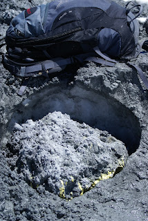
Volcanic blocks are pieces of solid country rock or rocks formed from previous eruptions, ejected from the volcano. Unlike volcanic bombs, which are ejected in a molten state as spurts of lava that may solidify in air or on the ground, volcanic blocks are nearly always angular and may be gigantic. The volcanic block above , found near the summit of Mt. Ruapehu, is slightly larger than a backpack (in the picture for scale) and has made a clear impact in the snow. This ejected material is more likely a volcanic block than a volcanic bomb because it is angular, does not have flow textures (common in volcanic bombs due to their molten history) and most interestingly the bottom border is covered in yellow sulphur crystals. Sulphur is commonly precipitated and crystallized in volcanically active areas, and due to this volcanic block's short life span (snow has not yet covered it and the last eruptive event for Ruapehu was within a year) it is more than likely that the sulphur had grown on the country rock before being displaced. Volcanic blocks and volcanic bombs are only a couple geologic hazards associated with volcanoes, along with others like lava flows, lahars, pyroclasitc flows, and corrosive ash falls that can collapse structures and cause airplane jets to clog and malfunction.


Amy Postcard 2

New Zealand is one of the few places on earth that still has glaciers. When glaciers begin to melt, often a river is formed. One example of this is the Waiho River in the South Island of New Zealand. Behind the river is the Franz Josef glacier. The river drains into the Tasman Sea. The water is very cloudy in color, and is very turbid and murky. This could be caused by the high amounts of precipitation in the area and high release amounts from the mountains behind the river. Throughout the river there are bigger boulders and rocks left there by the glacier retreating in the past. Also, glacier flour is left behind; this is from the glacier dragging over the bedrock. Also, due to the type of river that it is, you can often see rocks floating in the river. This is loose terrain from the mountain, where ice melts from the glacier and the debris that has acquired on the top falls down. Around this area you can see small moraines left that formed. As you look downstream, there is the Waiho loop moraine that is flat and was formed during the last ice age when the ice was retreating.

Amy's Postcards

Terraces can be seen all over New Zealand along with other parts of the world. Marine terraces can be seen on the North Island, New Zealand along the shore in this photo due to uplift events as a result of subduction occurring. The most recent event was in 1855, the Wairarapa earthquake which had an 8.2 magnitude. These marine terraces may have occurred during the last 10,000 years (Holocene). Marine terraces are wave-cut platforms that are ancient shore lines. They usually form as a result of waves that hit against the cliff and corrosion occurs. At these sea terraces, earlier sea levels can indicate reoccurrence intervals if dated. Older sea terraces are often more fragmented due to erosion processes. The terraces when standing at them are often clear cut; you are on a flat surface. Then you go up a few feet (slope upwards) and there is another flat surface, this indicates one of the steps up. Often scientists date shells and human artifacts (that may still be preserved where uplift occurred) to date back occurrence.

Champagne Pool


This steamy pool is located in a large area of surface thermal activity in the Taupo Volcanic Zone. It is a 700 year old explosion crater formed by a hydrothermal eruption. The diameter is 65 meters with a depth of 62 meters, making it the largest hot water spring in the district. The water would not be good for a nice swim. The temperature of the pool starts at 230 degrees Celsius and cools to around 74 degrees Celsius. Besides these scorching temperatures, the water is acidic with a pH of 5.4. All along the surface bubbles of carbon dioxide are released. By taking a closer look at the pool, you will notice this orange colored solid along the sinter edge. This is made up of arsenic and antimony. Gold, silver, mercury, sulphur and thallium are also found in the steamy water.

Mt. Ruapehu


One of the highlights of my trip to New Zealand was climbing and sliding back down Mount Ruapehu. Mt. Ruapehu is the highest point in the North Island of New Zealand at a height of 2797 meters. Between its high peaks, there is a crater lake that fills up between eruptions. This volcano is one of the three volcanoes located in the World Heritage Tongariro National Park, the first national park of New Zealand. This land was given to the world by the Maori to protect the land that is home to the volcanoes Mount Ruapehu, Mount Ngauruhoe, and Mount Tongariro Ruapehu is an active composite volcano that is always covered in snow and ice, making it popular for skiers, snowboarders and hikers. Since it is an active volcano, there is a danger of eruptions and lahars. There were eruptions in 1945, 1995, 2006, and 2007. During the most recent eruption, the Crater Lake partially drained into dangerous lahars. A teacher needed to be rescued from the Dome Shelter after crushing his leg during the 2007 lahar.

Turakirae Head


This area (seen in the photo) shows evidence of large scale uplift events through the presence of multiple marine terraces. These uplifts are caused by high magnitude shaking events that raise the land preserving past shorelines. Most of these earthquakes can be attributed to the Hikarangi Trough, a large subduction zone on the North Island, and other major faults that run through the area. The shoreline along the Turakirae Head consists of many marine terraces formed during the Holocene. The most recent marine terrace was caused by the Wyroba earthquake in 1855 with a Richter scale magnitude of 8.2, which raised the land 1 to 6 meters. The abandoned marine terraces form an anticline or convex fold in the ground. Many geologists have worked to date these terraces in order to help map a pattern of earthquake reoccurrence. They use various dating techniques, such as radiocarbon dating. Since radiocarbon dating can only date things up to 50,000 years of age, cosmogenic radionucleotide dating (CNR) is used to date cobbles found on very old high terraces. If a pattern of reoccurrence is developed, it could help to predict future earthquakes potentially saving the lives of many people. The photograph displays the multiple marine terraces leading up to the oldest ones. The older terraces can be identified by their fragmentation, which is caused by the years of erosion.

Tangiwai Railway Disaster


On Christmas Eve of 1953, a segment of the crater lake wall at the summit of Mount Ruapehu collapsed causing a massive mudslide or lake drainage filled with large boulders known as a lahar. Once a lahar begins to flow, it gains a lot of momentum and does not stop once it gets to the bottom of the volcano. It can continue flowing destroying anything in its path. This lahar continued past the mountain base and took out a railway bridge. An express train traveling to Auckland on this route was not warned of the gap in the bridge and went right over the edge leading to the death of 151 people. This tragedy is known as one of the largest disasters in New Zealand’s history. In the photograph, evidence of the lahar can be seen by the large boulders deposited in its path. The newly constructed railway bridge, which was built to avoid the path of a future lahar, can also be seen. Today, many geologists study and monitor the lahar paths and the status of Mount Ruapehu’s crater lake to prevent another catastrophic event from occurring. Although these precautions are being taken, danger still exists. The crater lake still contains a huge amount of water with a pH of 1 and a temperature of about 38ºC. The high acidity of the water adds to the erosion of the crater lake walls, which could ultimately lead to another lahar in the future.

Thursday, December 6, 2007

Emerald Lakes


The Emerald Lakes located on the Tongariro Crossing in Tongariro National Park were located in a large valley down the trail from Red Crater. The Emerald Lakes are three separate lakes that are a beautiful turquoise color. The smell of sulfur was overwhelming due to the sulfur deposits and is a tapu (sacred) site to the native New Zealanders. The lakes are quite acidic, however, when Kerry and others tested the water they were not harmed by the acidity. This spot interested myself because it was the perfect place to stop, dine on a delicious picnic lunch, and relax before continuing our hike.

Mud Pools


The mud pools located in Wai-o-tapu Thermal Wonderland were formed in 1925 when a mud volcano eroded due to heavy rainfall. Fragments of rock and glass below the surface heated up and expanded due to the magma under the rock and glass. The water heated in the process rises to the surface that typically creates geothermal activity such as geysers and mud pools. At the surface, clays have accumulated and hot water continually rises up to the surface creating blurping noises. The clay constantly changes due to rainfall so that it expands when there is high rainfall and shrinks when there is low rainfall. The clay is formed from bentonite which is a type of smectite. Different types of smectites are used in cosmetics such as foundation. This site is an interesting geothermal spot but is also an interesting spot to just sit and listen to the unique noises created.

Geo-post Cards- Colette Hyatt

Lady Knox Geyser

This picture shows a geyser found at the Wai-O-Tapu area in the Taupo Volcanic zone on the North Island of New Zealand. The geyser was named after Lady Constance Knox in May of 1903. It has two water chambers with one being lower and hot and the other being higher and cold. The lower chamber is heated by volcanic activity. This geyser was discovered by prisoners who were clearing bush in the area. They were using the hot water from the geyser to wash their clothes. They discovered that the washing soap could trigger an eruption. This occurs because the soap breaks the surface tension between the two layers and this allows the colder water to mix with the hotter. This releases pressure and causes the eruption. The eruptions can produce a jet of water up to 20 m and it can last for over an hour. Presently, 300g of biodegradeable soap is added at 10:30 am every day to create an eruption for visiting tourists. The geyser did not always look like it does in the picture above. The prisoners who discovered this geyser piled the rocks around the base. This was done to make a more intense and localized eruption. The eruptions have given the geyser the white silica covered cone-shaped appearance. This geyser is similar to Old Faithful found in Yellowstone Park of the United States.


Huka Falls

These falls are found on Waikato River that drains from Lake Taupo on the North Island of New Zealand. The Waikato River is the most highly developed river for electricity generation in New Zealand. This river supplies eight hydro stations and supplies cooling for two geothermal stations and one thermal station. These eleven stations produce 65 % of North Island’s power generation. Huka Falls have an average flow of 5,000 cubic feet per second. At the top of the Huka Falls there is a set of small waterfalls that drop over 8 m. and the final stage of these falls is an 11 m drop. In geological time waterfalls do not occur for long. Waterfalls show a change in the direction of a river system. The Huka Falls were created when an ancient lake drained Waikato River and eroded through soft mudstone and pumice. This occurred until it struck a layer hardened by silica. Over time the river then cut a deep narrow channel into the hard layer until it reached a soft underlying layer that collapsed. This created the steep-sided basin of the Falls.


Morgan MacCuaig


Hey Mom + Dad!

New Zealand is amazing! I wish you were here. I can’t wait to show you all of my pictures and tell you everything. We have seen so much interesting and cool stuff. This postcard is a picture of dead ice which we saw at the Fox Glacier on the South Island of NZ. Dead ice is a block of ice that breaks off of a retreating glacier when the glacier is retreating at fast rates. The block will become buried in sediment which acts as an insulator to the block of ice. Over time this block will become exposed and no longer be insulated, thus resulting in the melt out of the block of ice. As the ice melts it forms what is called a kettle lake. See you soon!

<3>

Morgan MacCuaig


Hey Mom + Dad!

Greetings from beautiful New Zealand! Just thought I would fill you in on some of the amazing and beautiful things I have seen. Pictured here is part of the Kura Tawhiti Park. All of the boulders sticking up along the hill side are called tors. They kind of remind me of the statues on Easter Island, but the tors are natural not man made. These towers of rock that rise from the ground are remnants of the limestone layer of rock that was corroded due to high rates of weathering over the past 12,000 years of post-glacial exposure. This weathering has also left a lot of little pock marks on the rock surfaces. These were really beautiful to walk up to and climb on. People were even bouldering on them which was fun to watch. Can’t wait to tell you more!

<3>

Kura Tauhiti- Rachel


One of my favorite stops on the South Island was at Kura Tauhiti near Castle Hill. When we first stopped by the side of the road, we could see huge boulders randomly spread out on the hills in front of us. It was a very interesting sight and our curiosity got the best of us as we wondered what they were and how they got there. As we walked up to the boulders, it was amazing to look up at their incredible height compared to the rest of the landscape, which were just grassy hills. I know I certainly felt small in their presence.
Upon closer inspection, we discovered these boulders were outcrops of sedimentary rock, due to the layering of the rock. We also determined the outcrops to be limestone because limestone is a soft rock, which weathers easily and into rounded masses. I could tell just how soft the rock was because people had carved their initials onto the sides of some of the rocks, as if they were wood. These boulders were mostly rounded remnants of weathering of the layers of sedimentary rock. Limestone can erode from natural acids and can be broken by joints where water dissolves or corrodes particles away. We also learned that these towers of rock were called tors, which form from increasing rates of physical and chemical weathering. The weathering gives the tors a scalloped look or honeycomb texture, which can be seen up close. We decided these outcrops must have been formed during the most recent mountain building period because if it had happened before the last ice age, glaciers would have destroyed the tors.
We had a chance to eat lunch there and explore the area on our own afterwards. This site was one of my favorites because not only was it interesting to look at and learn about, but it was also a lot of fun to climb up onto the rocks!

Lady Knox Geyser- Rachel


Lady Knox Geyser was the second stop we made while visiting the North Island of New Zealand. When we first arrived, we saw what appeared to be a large mound of dirt enclosed by a fence and stadium seating all around it. Excited by the promise of a great show, we all snagged seats as close to the action as possible. Soon a park ranger walked up to the geyser and introduced himself and his bag of soap he brought along for fun. The ranger gave us a brief history of the geyser before beginning the show. Lady Knox Geyser was discovered by a group of prisoners about 100 years ago. These prisoners worked by clearing the trees and shrubs from that area, which obviously left them quite dirty by the end of the day. The prisoners found the geyser and thought it would be a smart idea to bring soap so they could wash themselves in the water from the geyser. Of course, now we know that adding soap to the geyser makes it erupt, which must have been fun to see the first time the prisoners engaged in this activity. After this discovery, the prisoners began building up the cone of the geyser in order to make the eruption higher.
Lady Knox Geyser has a super heated reservoir of water underneath. There are two chambers of water: one contains water of temperature 200°C and the other contains cooler water, which sits on top and acts as a lid. The rocks underneath the geyser act as a heat source for the bottom chamber of water. As the water heats up, pressure continues to build up until the cooler water acting as a lid cannot hold it in any longer. Natural eruptions vary and depend on recent rainfall. They can last for about 45 minutes. Because natural eruptions are so unpredictable, rangers add soap to the geyser every 24 hours for tourists to see it. The soap makes the geyser bubble at first, then it softens the water and mixes the two water chambers to form a flash of steam. The white color of the geyser’s cone is from the silica that precipitates and builds up on the outer surface.
It was a lot of fun to see the geyser erupt and it was interesting to feel the water from the geyser hit your skin. The temperature of the water was a lot cooler than you would expect coming from a chamber of water at 200°C. It was also a great chance for some really fun pictures!

Amanda Bucci's Geopost cards

This is the site of the Tangiwai Railway Disaster located near National Park on the North Island of New Zealand. In 1953 on Christmas Eve, Mount Rupaheu’s crater lake’s natural volcanic ash dam collapsed, causing a mudflow, or a lahar, to plow through everything in its way—including the Whangaehu River, one of the main drainage paths of the mountain. An uninformed train carrying 285 people went over this bridge just minutes after the lahar came through, and as a result, the bridge collapsed into the river. Out of the 285 people on board, 151 died. This is the worst natural disaster to occur in New Zealand’s history. The high viscosity and high density of the lahar has enough momentum to move large boulders, like the ones pictured here. Since this tragic Christmas Eve, the railway company has installed signaling systems to alert conductors about broken rails, and Mt. Rupaheu’s crater lake is being highly monitored for any more dam failures that could cause another deadly lahar.


Pictured here is a moraine next to the Mueller Glacier where we conducted our geology field work on the South Island of New Zealand. In the background is Mount Cook, the highest mountain in New Zealand, and in the right hand corner is a picture of a lichen, which was the focus of our field work. Lichens are the premier pioneering species to grow on a rock after it has been deposited. By measuring the long axis of a lichen, and corresponding the measurement to years on a graph, scientists are able to tell the approximate age of the moraine that the boulder and lichen lies on. When a glacier retreats or advances, it leaves behind large boulder deposits and glacial till that forms a moraine. By dating the moraines, we can tell when the last little ice age occurred in that area. There is usually a 10-20 year lag time from when the glacier deposits the boulder and when the lichens begin to colonize. This means lichenometry data is quite accurate, and simple to obtain. The green part of the lichen is the algae, and the black part is the fungus. The algae fix atmospheric carbon dioxide that the fungi feed off. This symbiotic relationship provides scientists with important data to use in enabling them to date a moraine to determine when the last little ice age was during the late Holocene period.

Torie's Geo Postcards

LADY KNOX GEYSER


On November 17th we visited the Lady Knox Geyser in the Wai-o-tapu geothermal area. Originally the geyser was discovered in 1901 by prisoners who were clearly vegetation in the area to make room for the planting of pine trees. When the geyser was first found it did not have the tall snout on it that you can see in the picture above. The snout was added later as an effort to make the geyser spray higher. The geyser has two chambers of water underneather the ground, one cooler upper chamber and one warmer lower chamber. The upper chamber is cooler because of its proximity to the outside air and never exceeds boiling point and the lower chamber is warmer because of the hot magma underneath it and is about 150 ° C. Naturally the Lady Knox Geyser would erupt every 48-72 hrs but thanks to the help of some park rangers the geyser erupts every morning. Around 10 am the rangers add soap the the throat of the geyser and within minutes the geyser erupts sky high. The reason soap causes an eruption to occur is because it lowers the surface tension of the upper chamber and allows the two chambers to mix together. When the chambers mix together it causes the pressure within the geyser to increase and the only way to release the pressure is to force it up and out the throat of the geyser, causing an eruption! This Geyser is similar to our OLD FAITHFUL in the States!
REVERSED GRADIENT

On our last in New Zealand a colleague if Don Rodbell's, Jamie, came out to Twizel and showed us around the Tasman Glacier and a few outcrops. The out crop above was the second outcrop we looked at and was of a terminal moraine. With in the picture you can see fine well sorted sediment on the bottom of the cross section and bigger, poorly sorted sediment on top. This is known as a reversed gradient or a reverse grading system because normally what we should see is bigger boulder pieces on the bottom and smaller, well sorted sediment on top because heavier boulders fall out of suspension first. The reason this outcrop is different than normal has to do with glaciers. When a glacier does what is known as a glacier leap and bobs above the ground that it is stuck to and allows sediment to pass through the gap between the glacier and the ground. Since the glacier normally only has a small space between the bottom of the glacier and the ground only fine, well sorted material can pass through this gap and then settle out farther down stream. When the glacier gap gets bigger then bigger material is allowed to flow between the gap and thus creates what we see above, a reversed gradient where smaller, more well sorted particles of sediment are at the bottom and bigger, more poorly sorted particles are at the top. This outcrop was my favorite outcrop we looked at beause it truly showed me how sediment cross sections can really tell a story of the history that occured in a particular area!!


Emma's Geopostcards

Crater Lake


White Island is a volcanic island located off the shore of the North Island of New Zealand. On the island, there are a number of crater lakes, including this massive one. It is very colorful, and has white steam coming off of it. This lake is not made up of water that you would find in a typical lake, but is instead hydrochloric and sulfuric acids. The pH of this lake is -0.6, which is much less the pH 2, which is the pH of digestive juices in your stomach. The lake would literally digest you if you were to touch it. The lake fluctuates a lot in both height and temperature. It will randomly drop or rise in level, and is constantly fluctuating about 30 degrees. There is a major fear that if the water level of the lake were to rise to above the crater rim, it would spill out and down to the ocean. This would ruin the marine environment in the harbors and could have serious consequences. The landscape on the island changes so rapidly that it is unclear what the lake and its surroundings will do at any given time.


Mud Pool


This mud pool is located in the Wai-O-Taupo (sacred water) geothermal area, in Rotorua. In this area, geothermal heat is coming up from the Hikurangi Trough, where the Pacific plate is diving under the Australian plate. The mud bubbling causes a funny pooping sound due to concentration of water. It gives off the smell of sulfur, which is similar to rotting eggs. This mud pool phenomenon is caused by magma below the surface, which heats up water. This hot water is less dense, so it rises to the surface and bubbles up through the mud. The mud is made up of volcanic ash and glass. This volcanic material, which has piled up over time, alters to clay with the addition of hot water and shrinks when water is removed from it. This clay is expandable when heat is added and is called smectite. It is sticky and gluey, and can be used as a form of soap, or for facemasks, making it a popular beauty item.

Andrew Scaplen's Geopostcards

The Mudpots of Rotorua (Wai-o-Tapu)


The mudpots are a very hot geothermal area and can reach temperatures around 800º C. The heat comes from the Hikurangi Trough where subduction is occurring. This heats up water underneath the surface of the earth, which rises to the surface over the colder water because the hot water is less dense in comparison to the hot water. This unique geothermal activity produces constant bubbling, but periodic violent eruptions have been known to occur. The hot water from the subduction turns the ash and glass into mud, which bubbles to the surface in order to release the heat. The mud is made from bentenite and smectite, two groups of clay minerals. The glass and ash form clay when they come in contact with the hot water. This expandable matter forms the mud pools when the mud accumulates because the mixture of the glass in the clay and the hot water is unstable. Once the mud cools, it leaves a thin layer of hardened clay at the surface and around the edges of the mudpots. The mud has a greasy feel to it and is used by the cosmetic industry to create mud masks that dry out facial pores, leaving smooth, clear skin. The sulfur emerging from the bubbling mudpots leaves an unpleasant smell similar to rotten eggs. Currently the mud level is particularly low, but the thickness of the mud usually changes with seasonal changes.


Kura Tawhiti Conservation Area


The rocks near Castle Rock are made up of limestone, a sedimentary rock formed by the deposition of sediment layers of calcium and carbon over a long period of time. The rocks were deposited their by glacial movements from the last ice age. We know that they must have come from the last ice age because the soft limestone would not have survived multiple glacial advances. This gives them the age of approximately 12,000 year old (post glacial). The layers of the rocks are chemically weathered, forming a scalloped appearance. There are broken joints where water has percolated into the rock ad corrosion of the inside of the rock has occurred. Rain water seeping into the ground gradually weathered the bedrock forming cracks and joints and once this bedrock became exposed, particularly during the ice age, the freezing water expanded in the cracks and accelerated the weathering process. The ice molded topography also shows evidence of glaciation such as glacial groves and smoothed topography. You can also see signs of glaciation in the rocks from the striations in the soft limestone formed by moving glaciers that have formed abrasions. The repeated freezing and thawing of ice has formed an accumulation of water where constant weathering is occurring cyclically. Some ways to show that this rock is limestone without chemically testing it in the lab is the abundance of fossils which are very common to limestone. Another easy way to tell that this is limestone in the field is that limestone easily dissolves in an acid, so by putting some acidic (low pH) solution on the rock, if the rock fizzes, you know it is limestone.
Travis Blum's Geo Postcards


The Champagne Pool (Wai-o-tapo Geothermal Region)- The remnants of an old explosion crater that have filled with water from a source deep underground. The water is heated underground (up to 230° C) but cools as it rises in the steeply sided crater, creating a sinter (silica) lined pool with colorful deposits of arsenic and antimony sulfur compounds, as well as gold and silver (inset) as the dissolved minerals precipitate out. Named the Champagne pool because of the constant “fizz” on the surface of the pool as carbon dioxide bubbles vent from deep below the water surface inside the pool.


Bergshrund (Mt. Cook, New Zealand Southern Alps. Seen here from the Southeastern Side): A bergshrund is an initial crack in an ice sheet where it breaks away from the underlying bedrock. It is a characteristic feature found on all glaciers, and is an indicator of flow in the body of ice. Several smaller bergshrunds are visible here as horizontal cracks in the thick ice patches near the peak of Mt. Cook, but have not developed into full on glaciers as of yet. More precipitation, or colder temperatures are needed before these smaller ice patches can extend into recognized glaciers.

Fariha Ramay Geology Postcards

Champagne Pool, Wai-O-Tapu Geothermal Area, North Island, NZ


Champagne Pool, approximately 60 m in diameter and 62 m deep, is the largest hot water spring at the Wai-O-Tapu geothermal area in the Waikato region of the North Island of New Zealand. Wai-O-Tapu is located right on the edge of one of the four volcanic calderas within the Taupo Volcanic Zone, one of the world’s most active volcanic areas in the world. Champagne Pool occupies a 700 year old explosion crater formed by a hydrothermal eruption. The pumice material around the pool was also ejected by that eruption. Water enters the pool at about 72°C with a pH of 5.4. The surface temperature of the water in Champagne Pool is 74 °C and bubbles of carbon dioxide can be observed rising to the surface, giving the pool its famous name. As the water flows over the Artist’s Palette towards the Sinter Terraces, the temperatre drops to appromimately 15°C and the pH increases to 7.6. Minerals present in the water of Champagne Pool consist of gold, silver, mercury, sulphur, arsenic, thallium, and antimony which are deposited in the surrounding sinter ledge. The various sinter ledges have been associated with the tilting of the pool as a consequence of earthquake activity.

The orange, green/yellow, and grey colors in the Champagne Pool are the result of antimony oxide, colloidal sulphur/ ferrous iron, and sulphurous mud respectively. The orange-colored edge of the Champagne Pool contains arsenic and antimony sulphur compounds that are rich in minerals including gold and silver. The water overflowing the Champagne Pool is rich in silica, and as the water cools, progressively more silica precipitates and forms into a sinter. The Primrose Terraces have been forming for 700 years and are the largest in the southern hemisphere covering 1.2 ha (approximately 3 acres) since the destruction of the Pink and White Terraces with the eruption of Mt. Tarawera in 1886.


Huku Falls, North Island, NZ


The Huku Falls are natural waterfalls that are located close to Lake Taupo on the North Island of New Zealand and are the result of volcanic activity. Although these falls are not very high, the color of the water is a very unique shade of blue that is the result of very clear water reflecting blue light. The volume of water pasing over the falls varies between 32-270 m3/ sec. At the base of the falls is a dangerous undertow caused by the falling water plunging deep into the pool. Water temperature varies from 22°C in the summer to 10.5°C in the winter. The average daily flows over Huka Falls is 160 m3/ sec. The Waikato River (100 m wide and 4 m deep) is forced into a channel 15 m wide and 10 m deep upstream. The level of the River is controlled by Lake Taupo’s control gate bridge.

The pounding of water at the base of the waterfall is a powerful force for erosion. Even at the lip of the waterfall, the water gains extra erosive power as it accelerates when approaching the brink. Therefore, waterfalls are ephemeral phenomena, geologically speaking. While the surging water tears away at the base of the falls and removes its rock foundations, the scouring of the lip grinds back the brink of the falls and decreases its overall height. In geologic terms, waterfalls are quite temporary, and their presence is a sign of the unique geologic conditions that produced them.

Creation of Huku Falls:

An ancient lake once covered most of what is today the Waikato River Valley. Eventually, the lake drained and the Waikato River eroded through soft mudstone and pumice until it struck a layer hardened by silica from much earlier geothermal activity. Unable to erode this later, the river became confined to joints and fissures in the rock. Over the centuries, the river cut a deep narrow channel into this hard layer until it reached a soft underlying layer which collapses, creating the steep-side basin and the falls where the river plunges over the lip into the basin. Today the river continues this erosion process and the Huku Falls move upstream.

Rivers begin re-grading their courses and establishing a new curve of water erosion. Where the latter curve meets the former curve, there is a break in the slope of the river, called the knick point. The knick point usually forms a fall line over which descend the tributaries to the main stream.

The Waikato River System is the most highly developed for electicity generation in New Zealand. It supplies 8 hydroelectic stations and provides cooling water for 2 geothermal and 1 thermal stations. The 11 stations on Waikato produce 65% of the North Island/s power generation and approximately 25% of New Zealand’s hydropower, which constitutes 15% of New Zealand’s total power.


Wednesday, December 5, 2007

Prabighya - Geo Postcard


Braided Streams:
Braided stream was one of the most interesting features of a river system that I have learnt about during the trip. A braided stream is one where a channel divides into many small networks within the stream itself, in a pattern which to me appeared very much like its name suggests; braided. The characteristic feature of the braided river that we saw in Waimakariri river and Harunui river were that they were both in broad low land valleys adjacent to the mountain ranges. Although it is a river but the volume of water is very less and so the sediments are well exposed. This exposed sediment of the river bed is highly subjected to the effect of drying out due to the lack of enough water. This dry sediment provides an ample opportunity for the sediments to be easily affected by the wind action where the wind carries the dried out fine sediments and allows for loess deposition to occur in the wind blown direction. Loess is a blanket of un stratified , wind deposited fine grained sediment which is rich in clay minerals.
We also got the chance to see cloud of loess going above the braided river system of Waimakariri river during our drive.

Tower Karst Topography:
During our stop in Kura Tawhiti Conservation area which was about 920m from Castle Hill, we got to see some remarkable work done by nature on limestone which is a kind of sedimentary rock. Limestone is formed from layers of organic sediment deposited in deep oceans far from land. The resulting rocks can end up hundreds of metres above sea level during periods of mountain building. Limestone is composed of calcium and carbon which is soluble in the weak carbonic acids that are present in rain water which works on joints in soft rock, gradually enlarging them. Small differences is present in the rock structure and the solubility which leads to a wide range of pits and grooves and variation in structure that can be observed as each huge boulder is different from the other in terms of shape and structure. These sculptured landforms are the results.

Amanda Kern Postcards

Lady Knox Geyser The Lady Knox Geyser is named after Lady Constance Knox, the daughter of the 15th governor of New Zealand. It is located in the Wai-o-Taupo area of the Taupo Volcanic Field on New Zealand’s North Island. The geyser was discovered by convicts who were living and working in the region planting the largest man-made forest of pine trees, seen today on the hills beyond the geyser. The convicts were forced to live in rustic accommodations and took advantage of the hot springs for bathing and washing clothes. What the convicts discovered during their first bath, was that there was some sort of chemical reaction between the soap they used for washing and the water below ground which caused the geyser to explode. The convicts also realized that the smaller the hole through which the water could be released, the higher the geyser would spray. The cone formation seen today was originally a ring of rocks put in place by the convicts. Over time the cone has been coated with silicate rich water which solidifies in layers on a daily basis.

For the last 80 years, employees of Wai-o-Taupo Park have induced the geyser to explode every 24 hours at approximately 10:15am using the same reaction principle as the convicts, soap. Lady Knox Geyser is best thought of as a pipe beginning in a reservoir of water beneath the Earth’s surface and opening above ground as a geyser spout. The reservoir of water is heated from below by the Earth’s magma causing a build up in pressure. The heat is not able to convect and once the reservoir pressure exceeds the outside pressure, the geyser blows. It does not blow continually because the water in the spout is colder than the water in the reservoir. Adding soap breaks the surface tension and causes bubbles to rise up the spout. As the bubbles rise they bring with them water from the reservoir allowing the built up pressure to release in an explosion.

Lichenometry on Glacial MorrainesLichens are the ultimate pioneer species, meaning they are the first plant life to grow on recently exposed earth surfaces. Because of this, lichens are useful for determining the time of deposition for glacial morraines and therefore the time of glacial and inter-glacial periods. Glaciers deposit right and left lateral and end moraines as they retreat up valley. Moraines consist of a variety of material, including various sized boulders, which has been churned and piled up by the glacier during retreat. These boulders provide the perfect surface for lichen growth. By measuring and averaging the diameters of the original colonizing lichens across a morraine, an age can be extrapolated using a calibration curve. Difficulties arise when lichens begin to coalesce and determining the diameter of a single lichen becomes impossible. Also, lichen will often grow in a long, linear form and must be avoided in field or data can become skewed.

Sarah Holland- Postcard #2

There are many geological features present along the scenic Tongariro Crossing. The crossing passes through portions of both Tongariro and Ngauruhoe Mountain areas. The andesitic rocks that seem ubiquitous in this unearthly landscape show evidence of many lava flows over time. The volcanoes of the area are all stratovolcanoes. Eruptions are usually violent, and are followed by lava flow. The layering and jagged rocks in the area are both characteristic to lava flows. Cliff exposures include layers of very solid looking material sandwiched between layers of angular, unsorted substrate. The angular layer can be derived from two factors at play. Some of the material is colluvium, sediments (large and small) that gravity has pulled down the hill between eruptive events. Other parts of the angular layer is created during the cooling of lava flows. Due to exposure while traveling downhill, the outermost layer of lava congeals. As lava underneath continues to move downwards, it pulls the surface lava. This causes cracking, and piling of the recently hardened material. The valley that contains the first ascent of the Tongariro Crossing has a great deal of angular material which has been created by this process. The Tongariro Mountain area is still considered active.

Claire's other postcard


Shores of Lake Taupo

Lake Taupo, located in the center of the North Island, was created from the massive Taupo eruption, which released great quantities of ash and tephra into the air spreading over much of the northern North Island. Its shores consist of coarse volcanic sands which contain various minerals and volcanic rocks such as quartz, obsidian, and pumice. Pumice, a volcanic rock which traps gas as it cools, is very porous and light, enabling it to float on water. The shores of Lake Taupo have lines of pumice above the water where wave action has thrown them. Pumice deposits in banks up the shore from the lake show that the lake level has not always been at its current level, but has receeded from previous levels to its current state.

Sarah Holland- Postcard #1


Pictured here is a pumice terrace that marks the landscape next to Lake Taupo, on the North Island. Evidence of changes in water levels and other fluvial processes can be seen in the area’s many terraces which notch the topography. The pumice exhibited in the terraces was ejected over the landscape during an enormous explosion, possibly the Taupo explosion of 186 AD. The terraces have deposition layers of poorly-sorted and well-sorted material. The layers of well-sorted, finer sediment are volcanic ash. The ash can be deposited and redistributed for many years after an eruption and may also show evidence of stream or lake activity. For example, finer grained sediments such as volcanic ash are usually only deposited in low-intensity stream or wave environments unless they are of greater density than the larger substrate. In this case, since pumice is quite buoyant, the volcanic ash may have been deposited more easily. The poorly-sorted layers, where the pumice stones can be found, is evidence of not only an eruption, but also fluvial activity. The stones of pumice have been rounded, and in some areas, shingled. Both features are characteristic of the influence of streams on the landscape. For if they had been merely ejected and deposited, one would expect a more angular substrate. The youngest layer is eolian dust, or loess adding wind as another factor in the formation of this landscape. In summary, the pumice terraces have undergone processes of wind, water and time to appear as they do today.


Doug's Postcards (Otira Viaduct and Ngauruhoe)


Otira Viaduct
Upon first glance one may think this large bridge is spoiling the natural beauty of this spectacular, steep-sloped valley, but it undoubtedly demonstrates some of the difficulties faced while living in a geologically active area such as New Zealand. The Otira viaduct is a 440 metre stretch of road that connects two highpoints and spans both a river and a high frequency landslide path. The old road (located higher up the hill to the right) was constantly prone to rockfall, snow avalanches and landslides but was the only option until 1923 when the Otira train tunnel was completed as a way to accommodate heavy gold traffic. The road was also becoming increasingly unstable from the constant erosion of the base of the hill by the river at the bottom of the valley. This Otira Viaduct was the best solution that road engineers could come up with for this problem, but required a huge investment of time and money to build. The first foundations were poured in January 1998 and the first cars drove over the new viaduct in November 1999; costing New Zealanders a total of 25 million New Zealand dollars, the viaduct was deemed an engineering success! Many special features on this bridge were added due to the high geologic activity of this area. The combined high relief of this terrain with some of the highest uplift and erosion rates in the world caused engineers unimaginable grief while designing this viaduct. Besides the overall bend required of the bridge to traverse the topography, engineers also made this bridge forty percent more resistant to seismic activity than other comparable viaduct’s seismic maximums. They did so by incorporating 25 metre deep basal foundations for each pier, and adding triangular supports uphill of the two outer supports to help protect their integrity during landslide events (the middle pier didn’t receive one since it didn’t appear to be in a high frequency landslide zone). The difficulty of engineering design was also exasperated by the fact it is located within a national park, so the well-being of local wildlife such as the Kea (an endemic alpine parrot) was also placed at the forefront of importance when selecting bridge design methods. As part of the planning for this viaduct (which began in 1986) geologists obtained 14C dates of wood buried in landslide debris in the valley that suggests one large event occurred around 1900 years BP, that may correspond to the large eruption of Taupo during this time periof- though this has not yet been proven. One can only wonder how long this huge investment will last before being inevitably destroyed by the awesome powers of nature at work in this dynamic landscape.

Mount Ngauruhoe
(In Maori ‘Nga Uru Hoe’ means ‘throwing heated stones’)
Mount Ngauruhoe is a large (2,291 metres tall), young stratovolcano that first erupted about 2,500 years ago- making it the youngest vent in the Tongariro volcanic complex of the Central Plateau of New Zealand’s North Island. Although to many it appears to be a separate volcano, it is in fact a secondary cone of Mount Tongariro to the north. It erupted 45 times in the 20th century, making it one of the most active volcanoes worldwide in this period. It is New Zealand’s most active volcano having had over 70 eruptive events since 1839. Its most recent claim to fame comes not from its last eruption in February, 1975, but from its debut as Mount Doom in Peter Jackson’s The Lord of the Rings movie trilogy. The crater’s floor has steadily cooled since 1979, which may suggest that the main vent is becoming blocked (Snelling, 1998). Present in this photograph are many rocks of andesite (fine-grained equivalent of diorite) composition, which exhibit a ‘salt and pepper-like’ texture of dark mafic minerals mixed into a lighter felsic mineral matrix. Andesitic lavas are more viscous than basaltic due to slightly higher silica contents, but there is still evidence of lava flows here. Flows are evidenced by large angular boulders that have broken off after cooling on the surface of other mobile liquid lavas that carried these boulders down the slope. The best evidence of flows are further down the slopes out of the view of this photograph. Many of these rocks also appear to have small crystal sizes, and a moderate degree of vesicles which may mean the lava had little time to crystallize or allow volatiles to escape while underground. This moderate lava composition may result from the subduction of the (basaltic) Pacific plate under the Australian continental plate, reaching a critical depth, dewatering, and then melting these plates, sending the less dense lavas toward the surface where they eventually build up sufficient pressure and erupt. Also present in the foreground of this photo is some type of old inactive crater, which could represent a shift in active volcanism to the present crater around 2,500 years ago. The layering present on the far ridge of the old crater probably represent distinct volcanic events. Finally, in the old crater one can make out small alluvial fans beginning to form inside the old crater from the erosion caused by melting of large amounts of snow off Nguaruhoe each year.